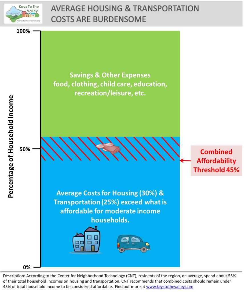
When the term “housing costs” is brought up, many of us default to thinking about the factors most directly related to the home itself – rent, mortgage, property taxes, utility costs, and home repairs. However, this does not include the full range of costs associated with housing choices. Where people live directly impacts their transportation options and relative costs. Accordingly, both housing and transportation costs affect people’s ability to afford a particular home. In the greater Upper Valley region (region) the average household pays 10% more of their income on housing and transportation than what is affordable (Figure 14).
Due to the rural nature of the region, the personal car is the primary mode of transportation. Personal cars are more prevalent among the region’s homeowners than renters. Only 2% of homeowners lack access to a personal vehicle, while 16% of renters lack access. Over half of rental households with access to a vehicle only have access to one. Homeowner households tend to have greater access to vehicles, with 70% having access to two cars or more. In many of our more compact communities with a higher proportion of renters, public transit is available in the village or downtown centers, but still limited outside of these areas. The majority of the smaller communities have no transit access, while those that do are limited. A population like ours that is projected to age can be linked to a higher need for transportation services (e.g., volunteer driver programs) for senior and/or limited mobility residents, including more investment needed for ADA compliant improvements.
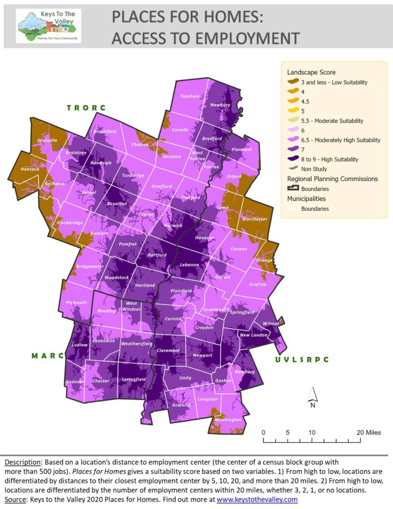
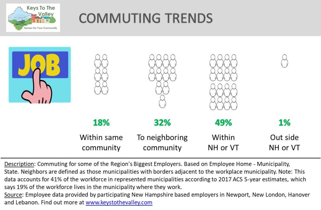
The work commute is a primary driver of transportation costs for many households. Using the road network, our Places for Homes scored locations across the region according to their proximity to employment centers, which contribute to a location’s final suitability score for residential housing (Figure 15). This analysis highlights the Upper Valley core where Hartford, Lebanon, and Hanover hold almost half, over 40,000, of the region’s jobs. The southern string including Ludlow, Springfield, Claremont, Charlestown, Newport, and New London each contain at least 2,000 jobs and combined nearly 20,000. Other small hotspots (dark purple) hold at least 500 jobs. These localized hotspots of employment alongside a shortage in affordable housing, means that for some of the region’s biggest employers, almost half of their workers must travel more than two communities away for a place to live (Figure 16).
Continued demand for housing units may push lower-income households further away from employment centers. If housing supply and affordability challenges are not addressed, this commuter trend could result in increased traffic on regional highways and increased cost of living for workers. Planning for housing and other land uses will need to consider impacts and connections to existing transportation networks, including public transportation and walking and bicycling networks. Notable communities with projected higher growth and no transit access include New Hampshire communities Grantham and the tri-towns surrounding Lake Sunapee, as well as the Vermont communities of Bradford and Newbury.
Multi-modal transportation options (walking, bicycling, public transit) will continue to be important for affordability and quality of life. Trends show increasing demand for livable communities defined as walkable and with access to employment, services, and activities, as highlighted in the Public and Municipal Perspectives report. Livability also has a significant impact on health and affordability as it effects access to health care, recreation, and healthy food. Walking and biking infrastructure is largely only available in our villages and downtowns, where integrating complete streets designs would further safe multi-modal access. A thorough understanding of current multi-modal access and gaps will provide communities with critical information to understand maintenance needs and prioritize improvements. Asset assessment protocols for walking and biking infrastructure are available in both states. In all our communities, transportation and land use planning is needed to ensure new housing developments are well-served and integrated into multi-modal networks. These networks might already exist or need to be prioritized for improvements in the next decade. For details on land use planning see our Land Use Regulations report.
We still do not fully understand the impacts of the pandemic on commuting patterns. Stay at home orders and work from home policies have reduced traffic volumes, but have also depressed transit usage. Whether these patterns will end up being permanent is unknown; however, that is mostly a benefit for higher-income households. Lower-income workers mostly still need to travel to work, and they are the ones that are most displaced by high housing costs in employment centers. Any in-migration the region may have experienced has not yet caused increased stress on transportation networks.